
In late January 2026, a formidable winter storm has emerged, spanning from Texas to New England, bringing with it a mix of freezing rain, sleet, and snow. The inclement weather has prompted several governors to declare states of emergency due to the perilous travel conditions, threatening wind chills, and potential power outages.
This harsh winter weather comes as a surprise after a typically mild winter, but experts suggest that the prior warmth may have intensified the storm’s severity.
Researching atmospheric phenomena and climate changes, scientists aim to deepen the understanding of extreme weather events, examining how such conditions arise and the influence of climate change.
To grasp the current winter storm’s dynamics, it’s essential to look up at the stratospheric polar vortex, more than 20 miles above the Earth’s surface.
Mathew Barlow, CC BY
The Anatomy of a Severe Winter Storm
Creating a major winter storm requires specific weather conditions to converge. Sharp temperature contrasts near the surface and a southward dip in the jet stream are crucial. Combined with abundant moisture, these conditions can lead to heavy precipitation in the form of rain or snow.
In this instance, a strong Arctic air mass has collided with warmer southern air, accentuating the temperature gradient. The Gulf of Mexico, with its unusually warm waters, is supplying the moisture needed to fuel the storm.

National Weather Service
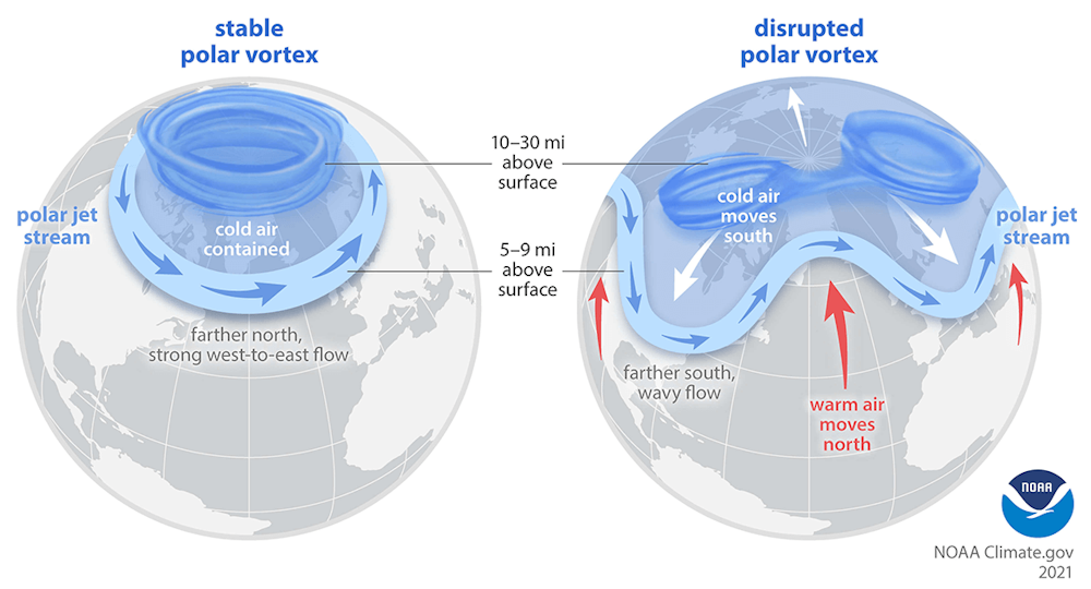
The Role of the Polar Vortex
The jet stream’s fastest winds occur just below the troposphere’s top, which is the atmospheric layer ending about seven miles above the surface. The stratosphere, extending from seven to about 30 miles above, interacts with the troposphere through atmospheric waves that can influence weather systems.
The term “polar vortex” often refers to cold Arctic air reaching the U.S., but it actually describes two circulations: one in the troposphere and another in the stratosphere. The stratospheric polar vortex, a high-speed air belt around the North Pole, sometimes extends southward, affecting U.S. weather by creating conditions for severe storms.

NOAA
The January storm’s forecast indicated an overlap between the stratospheric polar vortex and the jet stream, setting the stage for intense cold and snowfall. The interaction between these atmospheric layers can significantly influence winter weather patterns.
The energy dynamics in the atmosphere can cause pronounced swings in the jet stream, enhancing the potential for severe weather by reflecting energy between the stratosphere and troposphere.
Understanding Severe Winter Storms in a Warming World
Despite Earth’s undeniable warming due to human-induced greenhouse gas emissions, which leads to reduced snow overall, severe winter storms can still occur.
Research indicates that even with increased global temperatures, cold events may persist in some areas, although less frequently. Disruptions to the stratospheric polar vortex, linked to Arctic warming, could contribute to this.
NOAA
Warmer oceans lead to increased evaporation, while a warmer atmosphere retains more moisture, which can intensify storms. However, warming may also lessen storm severity by reducing temperature contrasts. These factors make predicting changes in storm intensity complex.
While average storm strength might shift, intense events could evolve differently. Evidence suggests that the most severe winter storms may grow more powerful. In warmer conditions, precipitation that once fell as snow may increasingly fall as sleet or freezing rain.
Ongoing Research and Unanswered Questions
Scientists continue to refine weather prediction models, though many questions remain. Federal agencies, including the National Center for Atmospheric Research (NCAR), play a crucial role in developing the data and instruments essential for forecasting.
Original Story at theconversation.com