With climate change escalating, extreme heat events are intensifying, leading to over five million global fatalities annually. These conditions pose severe public health challenges, especially in urban areas. Traditional heat risk assessments have struggled due to insufficient health data and geographically inconsistent risk factor impacts. This highlights the need for a spatially explicit, data-driven model for accurate heat-health risk evaluation.
Researchers from Zhejiang University’s School of Public Health, the Zhejiang Provincial Center for Disease Control and Prevention, and other Chinese institutes have developed an innovative model addressing these issues, as detailed in their study published in Environmental Science and Ecotechnology in August 2026. The study, accessible here, introduces a spatial model validated against real-world mortality data to enhance our understanding of heat-health risks.
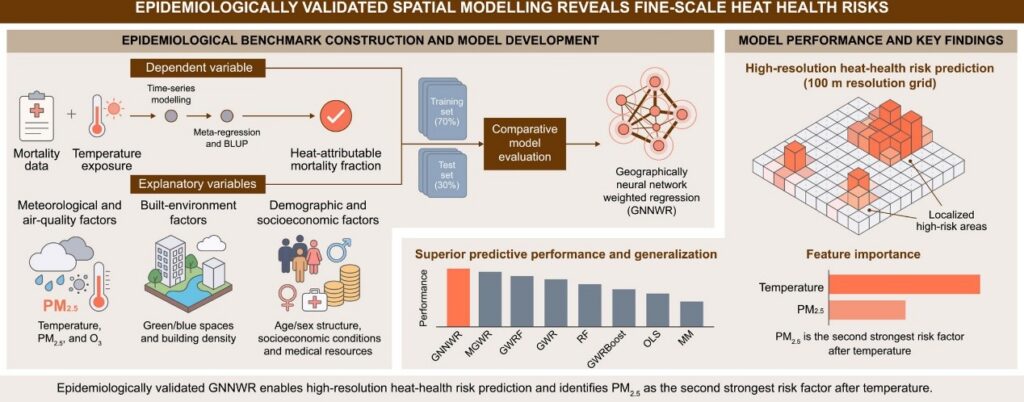
The core innovation of this research is the geographically neural network weighted regression (GNNWR) model. Unlike traditional models, GNNWR employs a neural network to discern how factors such as temperature and pollution affect health risks spatially. This model outperforms eight other models in predicting heat-attributable mortality, offering seamless risk mapping even in areas with incomplete health data. By capturing complex, spatially variable interactions, GNNWR provides a more comprehensive view of heat-related risks.
The authors highlight the model’s epidemiological and methodological advancements: “Our work introduces an epidemiologically validated spatial modeling framework that improves the accuracy and generalizability of heat-health risk assessment. Conventional composite heat risk indices often depend on predefined, expert-driven weighting schemes and typically aggregate indicators into several dimensions, such as vulnerability or adaptive capacity. While useful, such indices can be sensitive to subjective decisions, given that the weights of certain indicators are often ambiguous, and altering their assignment may markedly change the final risk assessment. More importantly, previous risk maps were rarely validated against heat-related health burden, leaving their accuracy uncertain. In contrast, our proposed framework avoids reliance on predefined indicator aggregation and subjective weighting by directly integrating standardized indicators as explanatory variables and using epidemiologically derived heat-attributable mortality fractions as the response variable. The modeling strategy enables risk estimation across multiple spatial scales, from high-resolution grid levels to coarse administrative units, allowing the spatial distribution of heat risk to be characterized at different resolutions.”
One unexpected revelation from the study is the significant role of fine particulate matter in heat-related mortality, second only to extreme temperatures. This insight allows for more targeted public health strategies by identifying the most critical risk factors in specific areas. The authors note, “This isn’t just a health issue; it’s a complex environmental equation. Our approach allows us to move away from one-size-fits-all solutions by revealing exactly which risk factors are most critical in specific neighborhoods, allowing for much more focused and effective public health strategies.”
This data-driven framework has transformative potential for urban planning and climate adaptation. By creating high-resolution risk maps, it identifies localized risk hotspots, aiding in targeted resource allocation. Policymakers can utilize this data to prioritize green and blue spaces and issue heat-health warnings with real-time air quality information. The approach is adaptable for other regions, even those with limited health records, providing a pathway to mitigate the health impacts of climate change globally.
Original Story at www.newswise.com