
A Surge of Hurricanes in the East Pacific: Hawaii, Baja California, and Beyond
The East Pacific hurricane season has been exceptional, making 2026 a year to remember. Three hurricanes—Lala, Lowell, and Nolo—have closely approached Hawaii, causing significant flooding and damage, yet none have made landfall. This year marks a historical moment as multiple hurricanes have passed within 50 miles of Hawaii for the first time. In a display of rapid intensification, Hurricane Polo surged to a Category 5 storm with winds reaching 180 mph in less than 24 hours. This makes it one of the fastest intensifying hurricanes recorded in the Central or Eastern Pacific, challenging Hurricane Patricia’s record in 2015. The basin’s Accumulated Cyclone Energy (ACE) has skyrocketed to 230% of its average, setting a new record.
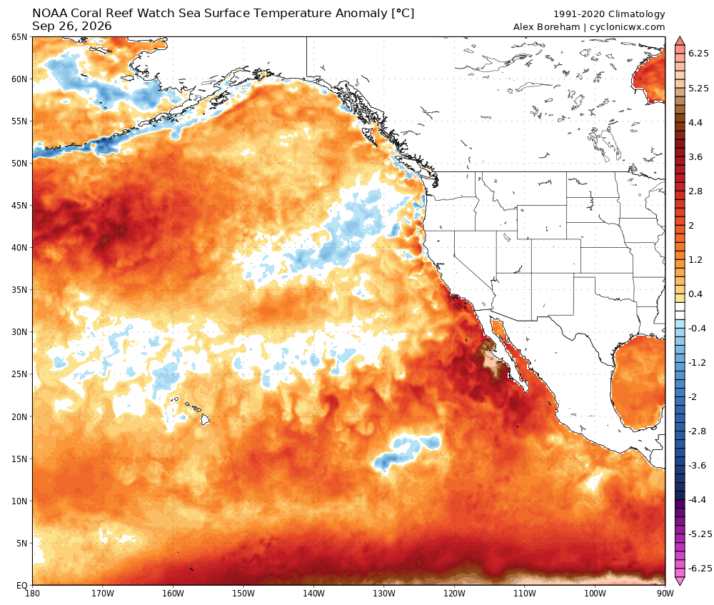
The phenomenon aligns with predictions related to a strengthening El Niño event, which has reduced vertical wind shear and warmed the Pacific’s ocean temperatures. While the East Pacific experiences heightened activity, the Atlantic remains relatively calm, also influenced by El Niño. This scenario reaffirms the seasonal forecasts initiated in spring.
California has intermittently received moisture from these hurricanes, with Southern California potentially experiencing brief showers from Hurricane Odalys’ remnants. Although the likelihood of further hurricane remnants affecting California in the immediate future is low, the possibility remains open for October.
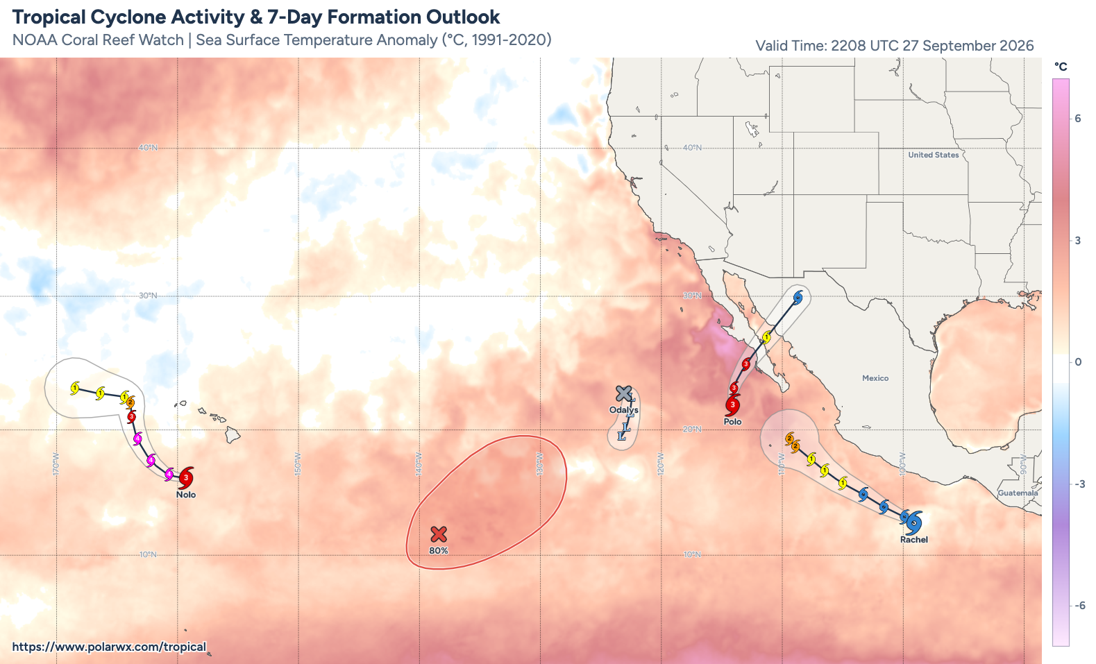
As Hurricane Polo approaches the Baja California peninsula, it is expected to make landfall as a Category 2/3 hurricane, bringing heavy rains to the typically dry region and likely causing flash floods. The storm’s remnants are projected to travel northeast, impacting the interior Southwest and Southern Plains of the U.S. with substantial rainfall. This is a double-edged sword in drought-affected areas, as the heavy rain may lead to floods, despite the need for water.
Meanwhile, Southern California braces for large ocean swells due to the series of hurricanes, threatening coastal erosion and potential bluff collapses. With tides already elevated and further sea-level rise anticipated, the situation demands vigilance. These coastal challenges are expected to persist as El Niño intensifies and the winter storm season approaches.
An Autumn Heatwave Looms Over the Western U.S.
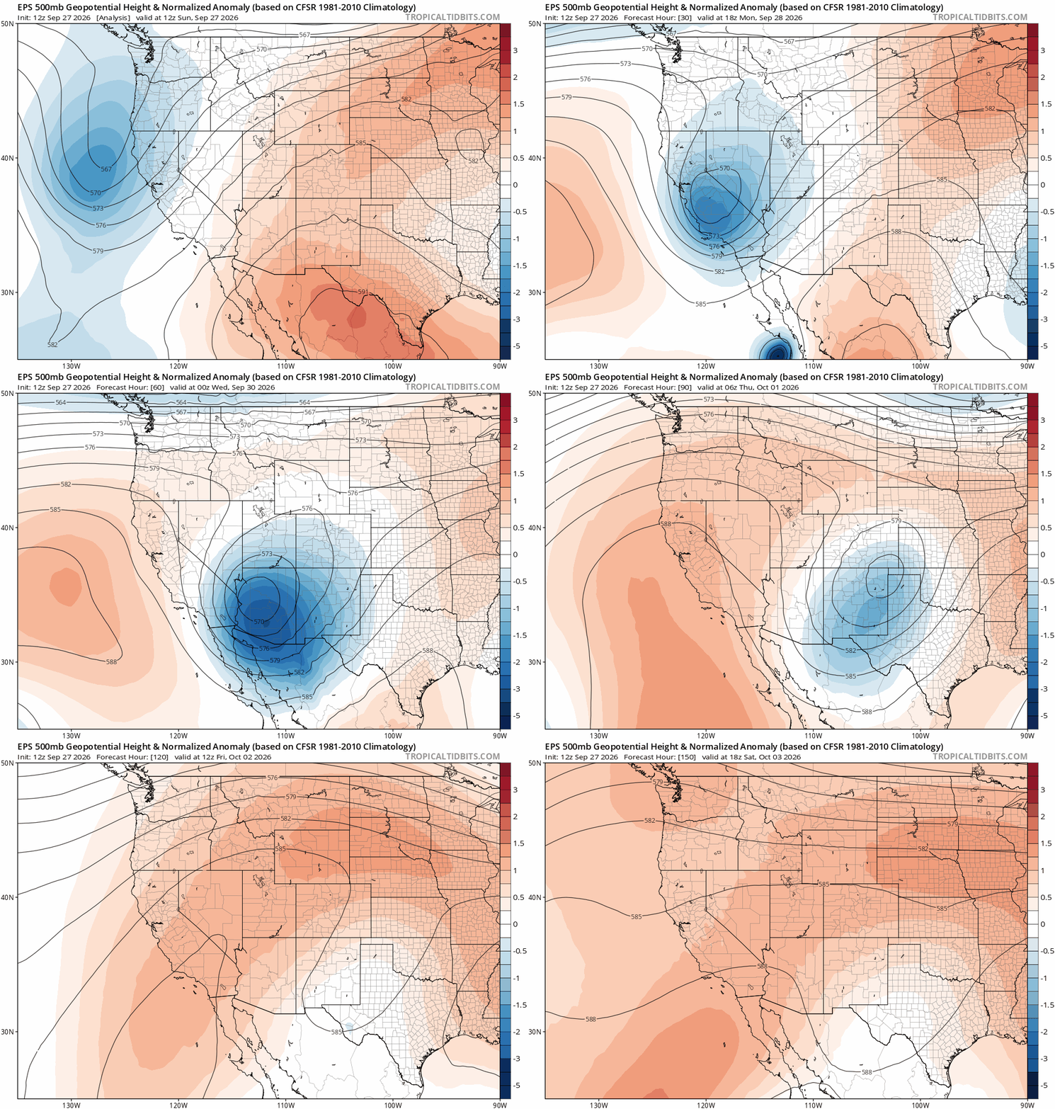
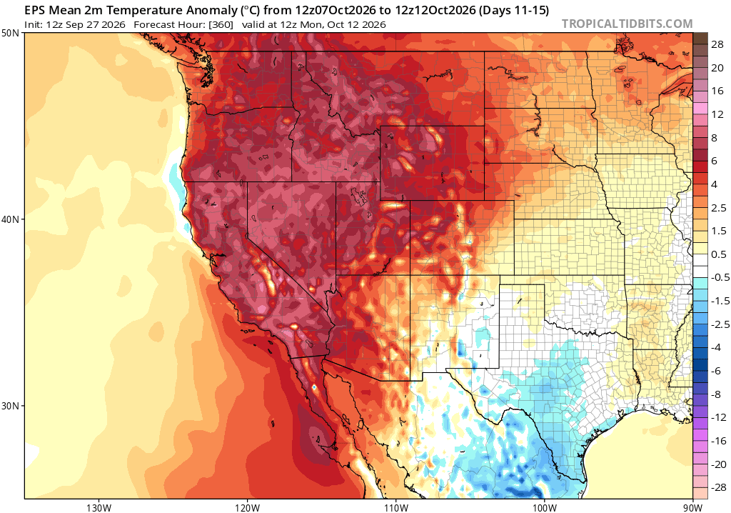
California is preparing for a significant autumn heatwave, expected to affect both coastal and inland areas of the state, as well as the broader western U.S. This heatwave, driven by a ridge of high pressure, is anticipated to last into mid-October. The elevated temperatures, unusual for this season, may lead to record warmth, particularly in regions like the Pacific Northwest and British Columbia, where early autumn cooling usually prevails.
In Southern California, increased humidity may amplify the health impacts of this heatwave. Although not as intense as previous heat events in August and September, the presence of moisture from tropical influences and warm ocean temperatures will contribute to the discomfort.
Fire activity, which has subsided recently, may see a resurgence in parts of the West not yet drenched by autumn rains. However, New Mexico and Arizona will likely be spared due to the moisture from Hurricane Polo’s remnants.
California’s Rainy Season: Awaiting El Niño’s Impact
The anticipation surrounding California’s rainy season grows as a record-breaking El Niño unfolds. While the state may experience a wetter-than-average winter, the effects of El Niño on precipitation patterns are typically more pronounced from January to March. Therefore, the dry or wet conditions from September to November are not indicators of the coming winter’s weather.
El Niño’s intensity continues to build, suggesting significant impacts such as coastal flooding and heavy rains later in the season. Further updates are expected in October as new model cycles become available.
Weather West: A New Era Without Ads
Weather West has gone ad-free for the first time in over 15 years, thanks to community support through memberships. While ads are gone, memberships now offer “thank you” livestreams as a new benefit. This move aligns with recent privacy law changes, which necessitated adjustments to how websites handle personal information.
Visitors to Weather West will now encounter a banner asking for cookie consent. Accepting cookies restores full website functionality, including comments and embedded content. These changes ensure compliance with privacy laws while maintaining the site’s content and community engagement.
Exploring Extreme Weather: A Conversation on Disasterproof
In a recent Disasterproof podcast, Weather West’s insights on extreme weather, climate change, and wildfire crises were discussed. This conversation highlights the importance of public investment in science and the role of technology in addressing climate challenges. The discussion was filmed at the NSF National Center for Atmospheric Research, emphasizing a collaborative approach to understanding weather and climate science.
YouTube Livestream: East Pacific Hurricanes and California Heatwave
Join Weather West for a detailed discussion on the active East Pacific hurricane season and the impending California heatwave on a YouTube livestream scheduled for Monday, Sep 28, at 3pm PT.
Original Story at weatherwest.com