Adam Fenech has dedicated 35 years to raising awareness about climate change, with the help of an assistant named CLIVE for the past decade.
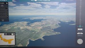
CLIVE, short for Coastal Impacts Visualization Environment, enables Islanders to virtually navigate over P.E.I. using a controller to adjust sea levels, illustrating the future impact of coastal erosion.
Developed in 2013, the program shares research and projections of coastal erosion, incorporating the latest coastal imagery from the province, an idea suggested by some of Fenech’s students.
Fenech, director of the UPEI Climate Lab, noted the immediate reaction from students during the first CLIVE demonstrations.
“I was hit in the back of the head by gasps from the audience. And I thought, ‘Oh wow, we’re really onto something here.’ This visualization is really effective. People’s concern went from high to very high,” Fenech said.
“Since then, we’ve always considered it a very effective tool for conducting vulnerability assessments and getting people talking about coastal issues.”
This month, Fenech is touring the Island with an updated version of CLIVE, visiting eight communities to show residents a glimpse into the future.
“I have to be very careful because it’s a very realistic visualization and people take it to heart. I’ve had people react very emotionally to seeing their houses swamped with water, as you can imagine. In previous tours with the earlier CLIVE, I’ve had people actually crying as a result,” he said.

“I’m hoping that they can judge their vulnerability and then take action, which is either move their structure further away from the shore or build up some form of protection.”
Protecting a shoreline, Fenech admits, is difficult and expensive. He said one goal of CLIVE is to convince Islanders not to build in areas threatened by coastal erosion.
“My main message is, of course, don’t build so darn close to the shoreline,” Fenech said.
“Like everyone else, I’m seduced by the ocean, so I’d love to live right on the coast, but it’s not a realistic option anymore on Prince Edward Island under climate change, in many places.”
Fenech said the visualization tool has been updated, using the latest imagery gathered by the provincial government.

“There’s been a great advance in the resolution of the imagery and in the way we can program things,” he said. “What we have now is a tool that has the whole Island in one scene that we’re able to fly over.”
Fiona ‘took huge bites’ out of P.E.I.’s coast
A study from a decade ago showed the annual average rate of erosion across P.E.I. was roughly 28 centimetres, or about a foot, according to Fenech.
While it might seem slow, it doesn’t take long for 30 feet of coastline in front of a summer cottage to vanish.
Adding to the speed of that erosion are events like post-tropical storm Fiona in 2022, Fenech noted.
“Fiona acted like a big great white shark taking huge bites out of our province. Certain places lost 15 metres in that one storm,” Fenech said.
“CLIVE is the virtual reality, Fiona is the reality.”
‘My house will be underwater’
Nora Scales attended the first presentation of the new CLIVE at Beaconsfield Carriage House in Charlottetown.
She first talked to Fenech about her summer house in Annandale in Kings County almost 10 years ago.
Back then, Scales wasn’t overly disturbed by the simulation, saying the erosion around her property didn’t appear drastic.
This time, it was a different story.

“The flooding is more imminent. It’s going to happen more quickly. It’s more drastic,” Scales said. “In 75 years, my house will be underwater.”
She described the coastal flooding simulation as “scary,” but also inevitable.
“It’s there. We have to deal with it. Climate change is a fact of life and those of us with properties on the water have to be sensitive to it,” Scales said.
“Would I buy another waterfront property? Probably not.”
Original Story at www.cbc.ca
